


History
Sham Singh Attariwala's Last Stand: Heritage in Jeopardy
by AMARPAL SINGH SIDHU
Some of the Sikh defences erected by the Sikh army before the battle of Sabraon during the First Anglo-Sikh War (1846) remarkably still survive in a badly faded state.
However, parts of these are being quickly destroyed by local farmers, who are rapidly appropriating any remaining uncultivated areas. Unless any government action is taken swiftly, no visible scar of the conflict will be left on this famous battlefield.
During my recent visit to the battlefield, I found farmers had already expanded their farms right up to the banks of the Sutlej, at many points destroying and levelling any remaining evidence of the battle.
This battlefield, like the others of the Anglo-Sikh Wars, has no protection from the Punjab Government. Other battlefields, like Mudki and Ferozeshah, are in heavily populated areas and all superficial evidence of battle has long ago been destroyed.
However, I found a small section of the Sikh entrenchments close to the Sutlej that has not been discovered, and appears, till lately, to have been reasonably undisturbed. Sabraon was the only battle where these sort of extensive field works were dug, in this case by the Sikh army.
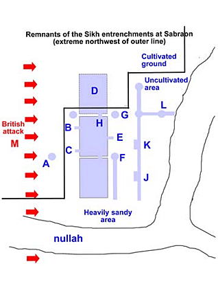
This piece of defence works was the westernmost of the Sikh entrenchments close by the river as shown on the map.
The Battle at Sabraon
Before the 10th of February 1846, the day of the battle, half of the Sikh army had been ordered across the Sutlej by Tej Singh and had dug in round the right-most section of the giant bend in the river north of the villages of Chote Sabraon and Rhodewalla.
They had organized defences and trench works around a perimeter of approximately two miles in length. The defences included fascines (wooden defences) and epaulements (bags filled with earth-like sandbags) in some areas.
However, Tej Singh had left the defences around the western side where a sizeable nullah flowed through the Sikh lines very weak and manned mostly by irregular troops, the least able to stop a determined British assault. No heavy artillery was placed here, only the much lighter Zambarooks or camel guns.
The fact that this area was by far the weakest had been communicated to the British by the treacherous Dogra Commanders of the Sikhs.
The camp itself was too small for the whole army, and most of the cavalry and considerable portions of the infantry and artillery stayed camped on the north bank of the river, unable to take part in the battle. This left less than half the army facing a much reinforced British force on the south bank.
Even had the whole army crossed, it would have been impossible from a logistics point of view to supply the approximately 40,000 men and 20,000 horses with their daily rations and ammunition via a single boat bridge. The position the betraying Dogra commanders had put the Sikh army in was an extremely weak one.
A matter of weeks after the battle of Sabraon and the end of the first Anglo-Sikh War, the British destroyed the wooden fortifications around the southern and eastern portions of the Sikh entrenchment which had been erected by the Sikh army.
This may quite possibly have been to stop the site turning into a place of pilgrimage - up to 10,000 Sikh soldiers had lost their lives here, including the much-revered General, Sham Singh Attariwalla.
What's left at Sabraon
The sections of the trenches dug in the extreme northwest that still survive are surrounded by cultivated land and live a tenuous existence, awaiting only the nearby farmers to level them for farming at some near point in the future.
I had followed the exact position of the line of the outer Sikh fortifications from the south eastern side along the Sutlej all along the path it had taken up to the northwest end where it met the Sutlej again. I found nothing left of value by the local farmers as far as the outer Sikh defence line was concerned, apart from these faded trench works to the north of the nullah flowing through the extreme northwest of the Sikh lines. These defensive works were exactly where they should have been according to British maps. The fact that they were so close to the river had protected them for these last 150 years.
In fact, remnants of the first Sikh line of defence, the bridgehead to protect the bridge of boats built to cross the river, also survived till a few years ago. However, I found the bridgehead defences had now been just recently been destroyed and the trenches and foxholes levelled by farmers.
If the battlefield had had any Government protection, the defences could quite easily have been saved and turned into a major visitor attraction, as interest in the Anglo-Sikh Wars runs deep within the Punjabi people.
As I walked around the interior of the Sikh lines, I found circular pits badly faded over time. Gough and Innis, in their book, The Sikhs and the Sikh Wars, among other sources, describe how the Sikh army had dug large pits capable of holding around thirty men. In fact, the Akalis in the Sikh army excelled in these fieldworks. Some of these pits are still apparent on the east side of the nullah. No pits survive closer to the river, as this area has been levelled by famers.
In fact, till a few years ago, most of the Sikh entrenchments area on the south side of the river, just over 0.5 square miles of land, had not come under cultivation as the area here is so prone to flooding. Earlier this year, during the flooding of the Sutlej, this entrenchments area was under several feet of water. However, regardless of flooding in the last few years, farmers have swiftly taken around 70-80% of this area. Only the most unpromising areas, traversed by nullahs and streamlets difficult to level have been left - mainly in the eastern portion of the entrenchment.
Description of the fortifications
The most obvious of the defences was two giant rectangular dugouts - each slightly less than 50m by 30m in length. A third rectangular defence can be seen, although largely been destroyed by farmers. These could have protected several hundred men from a cannonade or could have served as a cavalry trap for charging British horsemen while the Sikh soldiers manned a trench just behind these rectangular dugouts.
On three sides of the central square were normal circular dugouts or foxholes capable of holding two to three men each. In total, I found seven circular dugouts still surviving, all built near to the bigger rectangular dugouts.
All these manmade defences have suffered from flooding of the river and general erosion over the years and are heavily filled with soil due to flooding. In the case of the rectangular dugouts, the local farmers have started planting crops inside them despite their lower level than the surrounding fields. One still hasn't been used.
These dugouts were interconnected so soldiers could move from one to another without being exposed to British fire. Behind the rectangular dugouts were two trenches, again much faded after 150 years of neglect but still very obvious, along with some circular dugouts.
On their own, initially from ground level, they did not appear to make sense. Taken together and mapped, these dugouts and trenches form a fascinating image and detailed map of the defences made by the Sikh army at its weakest point and where the British would break through.
See Map (above, right)
This map is the only detailed representation of any of the Sikh defences at Sabraon. I don't expect these defences to last more than a few weeks or months, given the rapid level of encroachment by local farmers.
An explanation of the map is as follows.
Point A
This was a large dugout surrounded by cultivated fields. This may have been part of the defences. Each of the rectangular dugouts in the centre had small trench exits visible leaving them connecting them to the other areas. The trenches leaving the central rectangular dugout at points B and C suggest there may have been more trenches or dugouts to the west.
Point D
Only the southernmost edges of this dugout can be seen; the rest of it has been levelled by the farmers. An entrance at point H can be seen as an entrance from the middle dugout to dugout D.
Point E
There's evidence of a trench here leading from foxhole F to foxhole G, as an entrance from the middle rectangular dugout leads away at point E eastwards, but there are no traces of this trench now.
Points J and K
At these two points, the trench running from north to south widens somewhat.
Point L
A second trench here leaves the main trench and reaches the nullah allowing Sikh troops to cross the nullah without stepping out of the trenches on the western side.
Point M
The British general in charge of this section, Sir Robert Dick, was killed in the attack on the Sikh defences. Lord Gough, the British Commander, had placed the HM 53rd regiment at the extreme left of his lines, i.e., opposite these trenches
These defences should ideally have been placed behind the nullah, the nullah's eight- to nine-feet-high bank making it much more difficult for the attacking British troops. Instead, they were placed in front, perhaps another piece of treachery by the Dogra commanders. Forces led by General Dick on the British left flank overpowered these weakly manned defences fairly quickly.
With the Sikh right flank compromised, the British were only 500 meters away from the bridge of boats and the heart of the Sikh camp. Regardless of the situation in the south and east, the Sikh lines would have had to pull back towards the river to avoid being attacked from the rear by Dick's forces.
During my stay there, I believe I definitively located the position of the Sikh bridge of boats which tallies with British maps and firsthand accounts. The location lies close to where the nullah shown in the map connects with the Sutlej. This place really cries out for a monument of some sort to the 10,000 or so Sikh soldiers who died here trying to re-cross the river to the north bank.
In fact, this is possibly one of the loneliest and quietest spots in Punjab, far away from any village.
Little can be expected of the local farmers. Hungry for more land, any area with trenches or hillocks is now quickly flattened. As an outsider, I was met with not a little suspicion as I went around taking photographs of the Sikh camp area. Few if any people visit this battlefield, along with Ferozeshah, probably the most famous of battlefields in the Punjab and India.
No official signs exist and no memorials, apart from the ageing British obelisks, mark the important areas. The locals tended to assume the worst during my visit, that I must be a government official who may order seizure of their land if I find anything of interest there. Outsiders taking photographs of the land tend to make them very anxious.
The British demolition of most of the Sikh defences was an effort to destroy the importance of the Sikh Sabraon camp. Their efforts seemed to have exceeded their expectations. Few locals realize this stretch of land I was exploring was the site of the battlefield.
They assume the village of Chote Sabraon was where the battle took place, and that the Sham Singh Attariwalla Gurdwara close to the village was where the great general died.
In fact, Sardar Sham Singh commanded the eastern end of the entrenchment and died fighting bravely within the entrenchment.
All the battlefields need urgent attention. However, I believe only Sabraon, out of all the battlefields, has evidence of Sikh field defences remaining now and these may disappear in the next few weeks or months, as farmers quickly level what they believe is "waste ground".
Only quick intervention by the Punjab Government can save the last evidence of the Sikh entrenchments.
[Courtesy: The Anglo-Sikh Heritage Trail - http://www.asht.info/]
January 6, 2009
Conversation about this article
1: H. Singh (U.S.A.), January 07, 2009, 6:56 PM.
Sikh heritage preservation needs to be a constant endeavour of the Sikh People and NOT a one-time project of India. I believe we need to work on our own to preserve our heritage as nobody else is going to be as or more sensitive towards the importance of it. It is useless and helpless to ask for Indian intervention as India won't be sensitive to Sikh heritage, more so it will entrench crumbling priceless Sikh heritage into the corrupt hands of India's bureaucracy. So, let's have more confidence in ourselves. And get on with job ...
2: Gurbans Singh Atariwala (Richmond, British Columbia, Canada), March 20, 2009, 8:05 PM.
Dear S. Amarpal Singh ji: A great and commendable effort by you to research history and to take efforts to perserve it. I suggest we should raise finances through contributions and ask the Govt. of Punjab to contribute a similar amount and start work under dependable supervision to preserve the monuments.
3: Kanwalpreet Singh Brar (Mohali, Punjab), May 10, 2009, 3:15 AM.
It is a sad state for us that we as a community have forgotten the wars which marked an end of a great era and was the start of another, which continues till date. The Anglo-Sikh wars have been well documented from the British perspective. Is there any literature that provides the Sikh point-of-view of those fateful two winter months ending in Sabraon on Feb 10? You have mentioned you have taken pictures of the site. Will it be possible for you to provide more info/ pics. I am planning to visit the battlefields. Also, can we work on a forum where we plan such visits for friends who are interested to learn more of our heritage?